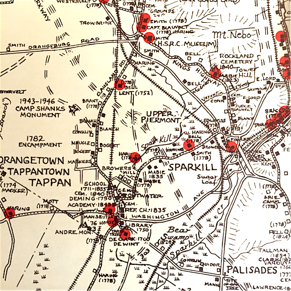
Kings Highway Landmarks. Source: Historical Society of Rockland County.
Here’s something historical you can do on a rainy Tuesday afternoon or a Thursday night: Journey through time on one of the county’s storied roads and follow the King’s Highway experience. Bob Goldberg presents a Historical Society of the Nyack’s Armchair Walking Tour on Tues Nov 15 at 2p in the Valley Cottage Library. There’s a repeat performance on Thurs Nov 17 at 7p at the Nyack Library.
To get you in the mood, here’s a story from last summer at the intersection of good health and great history: a bike tour of a Kings Highway, a Rockland County road with pre-revolutionary roots. It’s too far to walk and driving this route wouldn’t allow you read the signs and to savor the history. Upper Nyack resident and cycling enthusiast Mike Hays offers a third way to discover this lost road: on a bicycle.
Cycling Kings Highway
 Bicycling is the perfect way to cover a fair amount of real estate, to observe the landscape, and to give you the ability to stop anywhere and check things out.
Do all or part of this ride. Stop anywhere. Follow your eyes. Slow down.
Rockland County has almost as a many hills as it has cars. Understand your abilities. Think about bike safety above all else. Be sure to wear a helmet, obey traffic signs, signal turns and let cars go first. Generally cars will respect you if you respect them. Ride safe, ride often!
Kings Highways (or Kings Roads) were the interstates of the colonial era in America, connecting towns using widened ancient native pathways. Many of them still exist: if you have ever driven on US Route 1 anywhere from Charleston to Boston, you’ve shared the road with important American history.
In New York there was a Kings Highway on both sides of the Hudson River. To the East, the route ran from New York City to Albany, renamed the Albany Post Road after the American Revolution. West of the Hudson, you may be aware of segments of our own Kings Highway that ran through Rockland from Paulus Hook in New Jersey, to West Point and on to Albany. History and progress has obliterated a lot of the original 24-mile route in Rockland. But it still retains some of its original character and includes many points of historical interest, including stone houses, pre-revolutionary structures, churches and burial grounds.
Kings Highway in Piermont and Sparkill
What’s left of Kings Highway is best seen on a bicycle, starting with the road called “Kings Highway” in Sparkill and Tappan. It’s a mostly flat 17-mile ride beginning at Memorial Park in Nyack and heading south on Piermont Avenue to Piermont, probably the best 3.5 miles of cycling in Rockland. Turn right at Piermont’s only stop light and head up a slight incline on Piermont Road beside Sparkill Creek until you go under the 9W overpass. Go straight through the stop light onto route 340. The road goes uphill a bit and soon you will see the Mountain House restaurant (no, it’s not time for pizza yet). Turn right before the restaurant on Hickory Lane and prepare to take an immediate left onto Kings Highway. Be alert here. A lot of cars race down the hill from 9W on Hickory Lane.
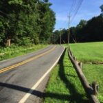 You will notice right away that this road is different–narrow and winding with a few short steep hills following the contours of the land. In the morning, the forested east side of Mount Nebo provides great shade.
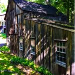
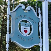 Almost right away you will see a sign for the Douglas House circa 1750 in front of a large restored clapboard house hidden by trees on the right. It is currently a commercial film location not open to the public. At one time this was the home of John Graham Bell, a taxidermist who taught the craft to Theodore Roosevelt, and traveled the Missouri River with John J Audubon, having two birds named after him, Bell’s vireo and Bell’s sparrow. Who would guess?
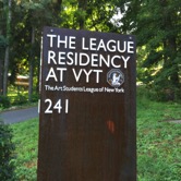 Soon after the Douglas House is the grounds of the Art Student League of New York Residency at VYT. The house and grounds were owned by modernist painter Vlasic Vytlacil who taught many famous artists at the school including Louise Bourgeioise, Cy Twombley, and Robert Rauschenberg among others. The league will have its final exhibition in July 2016 and no longer offer a residency program after October 2016.
Rockland Cemetery: Grave Site of a Republican Presidential Candidate
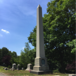
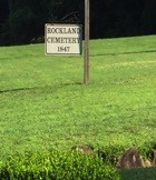 After these houses, the road suddenly widens out into a small field that is the entrance to Rockland Cemetery, established in 1847. The cemetery doesn’t allow bike riding, and the walk to the back part of the cemetery is nearly a mile. It is worth a visit at another time, as the graves include notables such as John C. Fremont, the Pathfinder, the self-proclaimed first governor of California, the first presidential candidate of the Republican Party, an abolitionist who was fired by President Lincoln in 1861 as the Head of the West when he announced that slaves were emancipated in his district. There’s also the grave of Henry Honeychurch Gorringe, born in the Barbados, a Civil War Naval veteran who later won the contract to move Cleopatra’s Needle from Egypt to its current location behind the Met in NYC. At its time this was the heaviest object ever to be carried on board a ship.
Kings Highway College Tour
 From the cemetery, Kings Highways winds its way for another mile through a residential area, the backside of St. Thomas Aquinas College and a senior center. You will probably hate me when you reach a turnaround point at a bank, Howard Johnson’s, and Route 303 across from an old stone house that is now Friscos restaurant. You must turn around here as the road ends at Route 303. Do not even consider biking on this road. (In a later ride I’ll talk about how to continue on Kings Highway north via a gravel road between Friscos restaurant and a bank.)
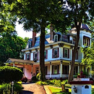
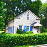
Retrace your route back to the Mountain House Restaurant, this time turning right onto Route 340 West and then making an immediate left onto another street labeled Kings Highway. This stretch of the highway goes through a residential area with a few older homes. First you cross the Joseph B. Clarke rail trail. Before you pass over the PIP you will see a small intersection with a Victorian house on the left and a small stone house on the right. After crossing the PIP you will end up at a stoplight at 303. I don’t know about you, but when I approach such a busy road, I realize how quiet and pleasant our back roads really are.
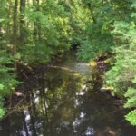
 Stop at the little bridge built in 1931 that goes over Sparkill Creek and imagine an old gristmill that was just upstream from here. Many of our waterways had mills along their banks at one time in the past.
Some Grizzly NJ History Buried in Tappan
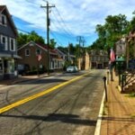
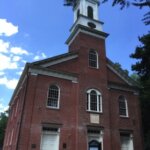 Continue into Tappan by turning left at the intersection of Kings Highway and Greenbush. This is such a lovely little town green that it merits a little time. I am struck by how few people walk here because there is so much to see. I got off my bike at the Dutch Reformed Church of Tappan and burial grounds. The church was first organized in the late 17th century. This very old cemetery includes the graves of a number of Revolutionary War veterans including those who died in the 1778 Baylor Massacre in River Vale, NJ. The current church building dates from 1835.
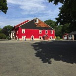
 The lovely tiny triangular green in the center of town across from the church is formed by the intersection of Greenbush Road, Kings Highway, and Old Tappan Road and once was the site of a Court House. Across the green is The Manse built in 1729 by the founder of Rutgers University, Domine Samuel Verbryck. Next to the Manse you can bike up to a big red barn that is still in use as an educational center and during WWII was used for USO shows for soldiers stationed at Camp Shanks. I briefly imagine my father attending a show during his short stay at the camp before shipping out to Europe.
 The tiny little Greek Revival house by the intersection between the green and the Tappan Cemetery once became a factory in 1900 under the ownership of Macey Demming who produced the nation’s first commercially available baby food made from soybeans.
The Traitor Buried in Tappan
") One of the most memorable Tappan residents was Major John Andre, the British officer who was captured in Tarrytown in 1980 with treasonous papers on how to capture West Point; they were given to him by Benedict Arnold (New musical idea: Benedict). Andre was an interesting individual who could speak four languages fluently, cut illustrations, draw, paint, sing, and write verse, and had lived in Benjamin Franklin’s house in Philadelphia where he purloined a portrait of Franklin. Andre’s loyalist wife was a close friend of Arnold. As head of the British Secret Service in America, Andre made friends with Arnold and met him in civilian clothes to obtain the West Point maps. After he was captured he was brought to Tappan, imprisoned at the 1776 House in Tappan, went to trial and was sentenced to be hung as a spy (General Washington’s payback for Nathan Hale.) To see the hanging site, head uphill on Old Tappan Road past a stop sign and turn left on Andre Drive. The monument isn’t very impressive; if you aren’t a André fanboy you can skip it without missing too much.
One of the most memorable Tappan residents was Major John Andre, the British officer who was captured in Tarrytown in 1980 with treasonous papers on how to capture West Point; they were given to him by Benedict Arnold (New musical idea: Benedict). Andre was an interesting individual who could speak four languages fluently, cut illustrations, draw, paint, sing, and write verse, and had lived in Benjamin Franklin’s house in Philadelphia where he purloined a portrait of Franklin. Andre’s loyalist wife was a close friend of Arnold. As head of the British Secret Service in America, Andre made friends with Arnold and met him in civilian clothes to obtain the West Point maps. After he was captured he was brought to Tappan, imprisoned at the 1776 House in Tappan, went to trial and was sentenced to be hung as a spy (General Washington’s payback for Nathan Hale.) To see the hanging site, head uphill on Old Tappan Road past a stop sign and turn left on Andre Drive. The monument isn’t very impressive; if you aren’t a André fanboy you can skip it without missing too much.
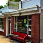 Returning to downtown Tappan, you will find Mimi’s Plate on the south side, a tiny but excellent breakfast and lunch spot. There is a small park for a picnic on the Sparkill Creek on Washington Street just past the street light on Washington Street.
 Return to the stoplight and head south on Main Street going past the beautiful stone Dutch-style ‘76 House restaurant that was first
 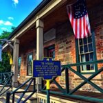 built in 1754 as an inn by Casparus Mabie. It was the very temporary home of Major André in 1780 during his trial. It is still a lively restaurant. Head down Main Street and turn left at Il Portico restaurant onto Oak Tree Road. Kings Highway is to the left and heads down into New Jersey. Be careful at this turn since you will have car traffic approaching blind from the right without a stop sign. Almost immediately you will pass over Sparkill Creek again, over a recently renovated bridge. The previous bridge had a mature elm tree growing in the middle between lanes until it was cut down in 1952.
George Washington Slept Here. (Really, he did.)
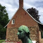
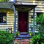
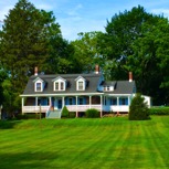
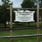 Very soon you will see a large open space with an old home on your right. This is the DeWint House built in 1700 and, yes, George Washington did in fact sleep here. He was here during the Andre trial, and he sent Andre his last meal. He also met General Carleton in 1783 to finalize the withdrawal of British troops. The house is open as a museum so feel free to turn right up the lane and into a small parking lot. You will find the restored stables and the characteristic Dutch style sandstone architecture from the early 18th century.
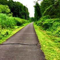 Now it’s time to head home, so return to Oak Tree Road and turn right. You will soon meet a stoplight on 303 (back to civilization, ugh.) Cross the highway and shortly after the light, look for a sushi restaurant on your right. When you see it look immediately left for a small parking lot sign and turn left into it. This is the southern end of the quiet carefree and carfree Joseph B. Clarke rail trail. You will pass under the PIP and enter Sparkill again.
You have almost made a circle by now (and if you parked in Sparkill you are done). Turn right on William Street, head downhill until you meet Route 340. You will see the Steakhouse on your right. Stop, and look both ways carefully, cross 340 onto Ferdon Avenue. Follow along the Sparkill Creek, cross over on the bridge just as the creek enters the marsh. You will see a stoplight and go straight north on Piermont Avenue retracing your way to Nyack.
If this is too much history (or cycling) in one day, consider these two shorter rides:
- From Piermont, park in one of the public lots, head to the stoplight, and turn right up Piermont Avenue. You will then be on the listed route. This will be about 10 miles
- From Sparkill, park downtown, head North to 340 and turn left. Do not go straight up the hill at the streetlight as this leads to 9W. You will then be on the suggested route. Total distance is about 8 miles.
Michael Hays is a 30-year resident of the Nyacks. He grew up the son of a professor and nurse in Champaign, Illinois. He has recently retired from a long career in educational publishing with Prentice-Hall and McGraw-Hill. He is an avid cyclist, amateur historian and photographer, gardener, and dog walker. He has enjoyed more years than he cares to count with his beautiful companion, Bernie Richey.
See Also:
- Historical Sites and Landmarks in Rockland Co. NY, RootsWeb.Ancestry.com
- Nyack History Explained, 7/25/2016
- The Kings Highway, John Scott, South of the Mountains volume 25 number 1.
- History of the Reformed Church of Tappan, 1894, David Cole, Press of Stettinar Lambert & Company.
- The History of Rockland County, Frank Bertangue Green, A.S. Barnes & Co, New York, 1886.
- Orangetown, The Orangetown Historical Archives & Museum, Arcadia Publishers, 2011.
- Popular Clarke Rail Trail to Add Miles, But Not Tappan Zee, 7/23/2013
Bicycle Rides and Clubs Near Nyack
- Bike Nyack, regular May-Sept Saturday rides in Rockland and North Jersey leaving from Memorial Park.
- Rockland Bicycling Club
- BTCNJ, Bike Touring Club of North Jersey